Before I went to San Ignacio, I decided I wanted to head
over to Guatemala and visit Tikal and Yaxha.
San Ignacio isn’t far from the border, so I thought it would be fairly
easy to get to Guatemala and see these two ancient cities.
Nope.
A day trip to Tikal was $140, not including dinner or the
hotel for that night. It was $130 for a
separate day trip to Yaxha, making both $270 plus one night in a hotel and
dinner for that night. That seemed
stupidly expensive to me, being used to Southeast Asian prices, so I started to
look at ways of doing it on my own.
Turns out it wasn’t that hard. When I got up in the morning I ate my
leftover chicken from the night before and bought some mango down the street to
munch on along the way. I also bought
bug spray and sunscreen at a local shop.
Then I took a $1 local bus to the last bus station before the border
(Benque), then grabbed a $2.50 taxi (shared with another woman, or it would
have been $5) to the actual border crossing.
It costs $16.50 to get through the border and it only took me maybe 30
minutes, including getting my money changed.
I found a taxi and had read that I should take the taxi to a spot called
El Cruce, a bus stop between Flores and Tikal, where I could catch a bus or
another taxi. However, I would have to
wait in that spot and hope to catch a bus at the right time, which is
difficult, time consuming, and unlikely as those buses are often full. The bus to that stop from the border cost $5,
and then the remaining hour taxi ride would have been $40. Or I could just take a taxi straight from the
border to Tikal for $50. So I did that.
My taxi driver was really nice, and it turned out that my
high school Spanish from 10 years previous actually stretched sufficiently far
to carry on a very detailed conversation.
He mostly wanted to talk about relationships, love, and sex, which was a
bit awkward as he was over 40, but he wasn’t pushy. He pulled over at one point to tell me he was
in love with me, and that if I moved to Guatemala he would treat me like a
queen, give his whole heart to me, and give me whatever I wanted. I asked if we could keep driving. However, he still offered to come back and
get me the next day and take me to Yaxha, wait there for me, and then take me
back to the border for another $50, essentially taking me to Yaxha for
free. The $270 for two days trips plus
dinner and hotel not included stretched really far. I was getting all my transportation for $100
(plus $10 on the Belize side), ended up finding a $15 camp site that provided
all the gear, $20 to get into the park and $10 for breakfast and dinner.
I camped that night at the Jaguar Inn, which was $15 for a
tent with a mattress, pillow, and blanket, and free usage of the outdoor
shower. The air was unbearably hot and
still, so that it felt like I was sleeping wrapped completely, head and all,
inside of a woolen blanket, but all told it was a pretty good deal
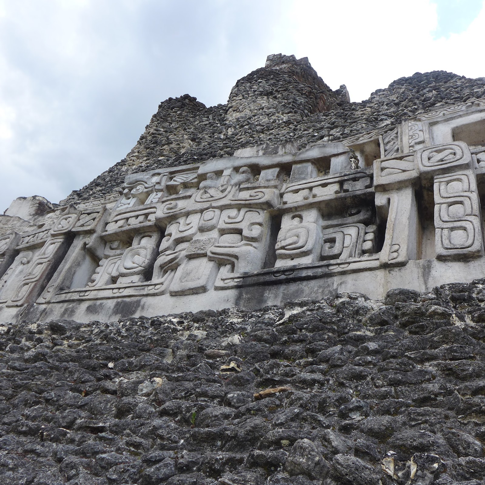
Tikal itself was absolutely incredible.
I climbed to the top of two of the biggest
temples and watched the sunset from the top of one of them (Temple 2).
I could also have watched from Temple 4, but
the west facing side of that structure was crumbling and a bit dilapidated, so
I opted for the safer route.
Which was
an unusual choice for me, in retrospect.
I saw howler monkeys, an ocellated turkey (which was weirdly
beautiful and repulsive at the same time), spider monkeys, a coati, and a
keel-billed toucan.
The toucan was
actually the first one I saw, and it’s the kind with the brightest beak: green
with a red tip, an orange smile-like slash, and blue underneath. I had just started walking into the park and
was studying my map, when I heard a small plop, like a stone being dropped into
a pond. I look over and saw a small
stone square filled with water, and then looked up and the toucan was just
above it, about 5 feet away from me. I
was so surprised when I saw it that I immediately said, “Oh my god!” which
scared the toucan. It flew off before I
could reach for my camera. The other
animals were around various areas of the park.
The park was rather large, if I’m being honest, and was at
times difficult to navigate. Part of me
wished I had a guide, but the map was fine, to be honest. The park is so large that it’s difficult to
get all the way around it in one day, so I didn’t put too much pressure on
myself and just decided to hit the big sights and find whatever else I wanted
from there, without worrying to much about the percentage of the park I was
seeing. It was also 104 degrees that
day, and a lot of the park is not in shade, so I had to take a lot of
breaks. Every time I saw a vender
selling water I would buy 2, chug one, and save the other for the walk until I
found another vender.
Many of the ruins at Tikal are not excavated all the way,
both because there aren’t enough funds and time, and also because sometimes
they begin excavation and find the ruins to be too dilapidated to fix, so they are
forced to re-cover them. Even though
they appeared from the outside to merely be very steep hills, with pictures
nearby of what is under the dirt and trees (they’ve surveyed the land to see
what various things look like), it was still very interesting to think about
what it all must have looking like hundreds of years ago, when the city was a
bustling metropolis. It was completely
amazing to think about people walking those same path sand climbing those same
buildings thousands of year ago.
In the central pavilion, where Temple 2 was located, there
was also the North Acropolis, the Central Acropolis, and the Jaguar Temple
(also known as Temple 1).
It was the
most impressive part of the park. Jaguar
Temple is closed for climbing, but you can walk all over and around the rest of
it, though you have to take care to use the proper paths and staircases so that
you protect the architecture.
Apparently, it was okay to climb Jaguar Temple up until 1987, and the
attitude was always the same as it is now with climbing: do so at your own
risk. However, at least one or two
people died almost every year climbing the Jaguar Temple, and in 1987 there
were three by May, so the government decided to close it.
I ate a super cheap shitty dinner at one of the comedores
nearby (there are a few along the road approaching the National Park and the
hotels) and then went to bed, wanting to rest before waking early the next day
to head to Yaxha.
My driver picked me up at my hotel the next morning and we
were once again off, this time to Yaxha.
The taxi ride was interesting once again. We talked about religion, and I got educated
on Catholicism. Then we talked about our
families and the presidential race, and all the jobs he’d had over the years, working
in Tikal and driving a public bus. As we
turned off the main road and got onto the unpaved road for Yaxha (it was only
15 miles but it took almost an hour because the road was so bumpy and unever)
he rolled up all the tinted windows. It
was unbearably hot, but he said that side roads, particularly unpaved ones, can
be very dangerous in Guatemala, especially if they can see a white person
inside the car. He told me that once
when he was a bus driver they gave him a different route than usual, and on an
unpaved road he was pulled over by some soldiers holding guns. When he saw them closer he realized they were
wearing the wrong boots, which meant they were probably guerillas of some kind,
but he had already stopped. They made
everyone get off the bus and get on their knees, then stole all the people’s
money and jewelry. Then they noticed an
especially beautiful young girl, maybe 15 years old, and took her back onto the
bus where they proceeded to take turns raping her for 45 minutes. Then they let everyone back on the bus and
let them go.
I was fine with the heat.
Yaxha was really cool, although in many ways unimpressive
after Tikal. The actual ruins are much
closer together and more localized than Tikal, which was nice, and they are all
located in fairly dense rainforest, so it was shadier and cooler than the day
before. It was also a lot more rustic
and secluded. The entire city was up on
top of a hill over a lake, so the views from the top of the various towers were
absolutely incredible.
It was totally
worth 2 hours of hiking. Yaxha also had
a much better excavated ball court than Tikal, which was interesting because it
made it easier to understand how the game was played, from a visual
standpoint.
The ball was made of rubber
from one of the trees, but was dense and heavy.
Players were trying to get the ball through one of two hoops on opposing
side of the court. The hoops were like
sideways basketball hoops, with the hole facing side to side rather than
straight up and down. Players used their
hips to bounce the ball up through the hoops.
All the architecture in general was pretty cool.
There was also a P.E. class hiking through Yaxha. They were kind of funny- they kept teasing
each other to talk to me, saying rote English phrases and telling me their
names, then giggling and running away.
When I got to the border it was easy to get back to San
Ignacio, but I forgot my Nikes at the bus station. When I got to my new hostel, (The Old House
Hostel, which I highly recommend) I asked if I could call about them, but the
guy who ran the hostel said, “Forget it.
They’re already gone.”
I met a British
couple named Alice and James and booked the ATM tour with them, and then we got
food and cooked some dinner. I also met
Jan, and Swiss man, Angelica (a Croatian woman), and Julia, and 21 year old
from Arizona that I spent most of the rest of the trip with.
We spent a day in the ATM caves (which I already wrote
about) and then the next day got back to seeing temples. Julia and I took the local bus to the path
for Xunantunich, a much more easily accessible set of ruins. You walk down a short path to a ferry across
a river. It was pretty funny- the ferry
could carry cars, which made it about half as long as the river was wide. It took maybe two minutes to chug all the way
across, which they did using a hand crank.
Then we had to hike up hill in the sun for about 20 minutes until we
reached the museum. It was a little
tough in the heat if I’m being honest, but the taxi ride there would have been $30 and it
wasn’t worth spending that.
James and Alice told us they had met a man who was going to
start excavating some of the ruins soon, and said that talking to this
archaeologist in the museum was one of the highlights for them. He wasn’t in the museum when we walked through,
which was a little disappointing. The
museum itself was very interesting and informative though, and we were excited
to see the ruins, which were only a little further up the hill.
Xunantunich is particularly known for a stele on one side of
one of the temples. Archaeologists were
worried about the stele being destroyed by the elements and by people coming
in, so they built a replica stele right on top of the ancient one.
I had brought my Blazer jersey so I could take
some photos for “Wear in the World” a segment they do during games where they
show people wearing their Blazer gear all over the world. As we walked down from the main temple, we
noticed a bunch of people on a hill that looked like an unexcavated
temple. We headed over that direction
and some yelled my name and then said “There’s someone from Oregon here!” I got confused until I met the other girl
from Oregon, who was from Eugene, and who has the same name as me. She told us all about the excacation they had
just begun that morning, and we got to watch for a little while, as well as
speak to the lead archaeologist. It was
super informative and interesting.
The
rest of Xunantunich is really more for looking than for climbing, as there are
only a few more small temples and a small acropolis, but it was still very
interesting.
The walk back was easy, and we kept seeing grey iguanas
climbing over the rocks. We went back
and grabbed lunch. I got Escabeche, a
Belizean chicken and onion soup made of pure deliciousness. I want it always and forever. It would actually be an even better chicken
soup for when you’re sick because it’s a little spicy and would probably clear
out your sinuses. Mmmmmm.
After that I left to catch a bus to Orange Walk, a city up
toward Belize City, so that I could see Lamanai the next day. Julia wasn’t interested, so she stayed in San
Ignacio and went to Caye Caulker, the beach, the next afternoon. I met up with her there after I finished at
Lamanai (I caught a bus to Belize city really awkwardly, just made it stop
along the road between Orange Walk and Belize city right after I got off the
boat the end of my tour. Then I ran from
the bus station to the water taxi and caught the last one to Caye Caulker and
thank GOD because you do not want to stay in Belize City).
The bus to Orange Walk was nice. It wasn’t the local painted school bus kind,
but the air conditioned long distance type buses we’re more accustomed to in
the states. And it was still only $8 for
a two hour ride. The town of Orange Walk
itself, however, was terrible. There was
nothing around, everything was dirty and there was tons of traffic. My hotel was grimy and the owner was a total
Negative Nancy with a sour face and a bad attitude, who talked about how much
he hated Belize and how much better Taiwan was.
There weren’t really many other budget options though, so I stayed.
I walked down the street and sat on a stool in front of a
hut, where I bought two rounds of 3 taquitos for a dollar. The old woman at the shop only had frozen
water to give me, but I said it was okay because it would still be cold in the
morning, and she laughed really hard.
Then I went back to the hotel and took a cold shower. The water was warm by the time I went to bed,
only an hour later, because it was so hot there.
Lamanai the next morning, however, was amazing. The day trip including lunch, transport by
van and boat, and a tour guide only cost $50, so I had no problem doing that. It was me and two other families, both
American, with our main tour guide and a trainee that he was helping pass her
exams. The boat ride was around an hour
and a half, and we saw a lot of wildlife along the way. There was a crocodile, tons of birds,
lizards, snakes, and a spider monkey we got to feed.


When we got there, it also had a museum that was highly
informative. We started walking around
the grounds, and our guide showed us obsidian that he picked up right off the
ground in front of us. Even back when
the Mayans still lived in that city, obsidian had to be brought in and traded
for from other places, just like the jade they had found in the city. The first temple, the Jaguar temple, had a
body in it that archaeologists discovered wearing a jade mask, a sign that the
person buried was considered a living god.
It also had two steles on either side of the stairs, smaller than the
one at Xunantunich, but still very cool.
There was also a ball court where they had discovered liquid
mercury buried, a product that they have no idea how the Mayans either made or
discovered it.
Across from the ball
court was the tallest temple at the complex, which had a great view from the
top.
There was a Stele temple that had a
huge rock with a stele of a Mayan god on it (the original was in the museum,
but there was a replica at the site as well).
That temple also had a body interred there, which was of someone they
think was a king. The final temple we
visited was the Mask Temple, which was my favorite. It had two large masks on either side of the
steps, with faces coming out of jaguar mouths.
While we sat there my guide and I were talking and he stopped and asked
if I heard something. We sat in silence
and then I heard this deep vibration noise that sounded far away. He asked if I’d heard it, and when I said I
had he told me it was a jaguar. I said I’d
heard that there were only 15 in the wild in Guatemala. He shook his head and said, “That’s
Guatemala. The preserve here estimates
that they have 200 jaguars there, and more in the rest of Belize, too.” We heard the jaguar again and it was definitely
amazing.
The Mask Temple, our guide told us, is a site of some
contention, according to him. For most
of archaeological history, it has been contended that human sacrifice never occurred
among the Maya of Belize. However, ATM
has caused some controversy on that point, as has the Mask Temple, where
archaeologists uncovered the bodies of five children. None of their bones were broken, so it was
assumed that they had not been sacrificed.
However.
Belize has a special tree that the Mayans called the “Give
and Take” tree. It has spines all over
the trunk. Scratching yourself on one of
these spines will give you instant searing pain and fever. The only way to stop the pain and cure the
fever is to rub the scratch with cotton covered in sap, found inside the
tree. So the tree gives the pain and
fever, and it takes it away.
This tree was used in human sacrifices. There are spots on the body that, when all
are cut, will cause a person to bleed to death relatively quickly. However, that was not quick enough for the
Mayan sacrifices. So they would take
some spines and put them in the person’s tongue and genitals before cutting them,
so that the pain would cause them to flail around in agony, which would cause
them to bleed out faster. BRUTAL. However, this form of sacrifice would leave
no evidence on the skeleton, and would certainly leave no broken bones. It has been hypothesized that perhaps the
children found in the Mask Temple were sacrificed in this way.
On the way back to the entrance we walked through the royal
chambers, and saw Mayan beds, which were stone that was covered in straw to
make it more comfortable. The rooms were
all small because they were used only for sleeping, as the Mayan people spent
most of their time outside.
Lamanai was also an interesting site because of its
history. It lasted much longer than
other cities because of its access to fresh water from the river. It has long been hypothesized that the Mayan
civilization met its end in part because of drought. Lamanai would not have been as heavily hit by
a drought as other cities. It was also
an ancient city, with evidence of people as far back at 1600 B.C. The last people left in the 1600s, when white
people came to build a sugar plantation and brought diseases. The Mayas there thought the diseases were a
sign from their gods that it was time to abandon the city.
The ruins of Belize and Guatemala were truly
spectacular. A short guide for those who
would like to know:
Best: Tikal, Lamanai, Yaxha, Xunantunich
Easiest to Walk Around: Xunantunich, Yaxha, Lamanai, Tikal
Easiest to Get To: Xunantunich, Tikal, Lamanai, Yaxha
Most Photogenic: Lamanai, Tikal, Xunantunich, Yaxha